


 Another nine days of howling tradewinds came to an abrupt end last night, as the interminable high pressure was finally nudged away by an intrepid Alaskan low. (Thanks Jack!) I heard the guys were planning on flying the lighthouse ridge at Makapuu, but somehow I got the crazy idea to head in the opposite direction, to investigate the possibility of soaring Dillingham. And somehow I convinced Ray and Jon to join me out there. We don't know much about how that place works, but I figure it's always worth some more research.
The forecast had described the light southeast airflow that caused us to be drenched by the Big Island moisture plume last night, and it also said sea breezes would determine the local airflow today. Most sensors were reporting a light north breeze in the morning, including the one at Dillingham. I drove out there and was happy to find sunny blue skies, but I was disappointed to find very little wind at all. The sensor was now reporting a halfhearted two miles per hour.
My faithful friends Ray and Jon soon showed up, and we managed to convince each other to hike up despite our worries about the lack of wind. After about 45 grueling minutes and a thousand vertical feet, we reached the top, where the cycles still seemed quite light, barely enough to convince us to give it a shot. We figured we'd be lucky to get sledders, but at least it was a beautiful day for it. By this time we were hearing reports of some watery misadventures at Makapuu, and we were hoping to avoid any misadventures of our own at this very committing launch site.
We sent Jon off first, and on his second attempt at a forward launch he made it into the air, startling a tow plane into an early release of his glider. But instead of sledding down, Jon actually started to go up, and after a couple of passes he was quite a ways above launch. Ray and I let out a cheer of happy surprise. The ocean was starting to show a smooth uniform texture, and our hopes were raised for good soaring conditions. Ray went next, ripping his wing into the air reversed, then spinning and hesitating a moment before loading up his wing and running off the cliff into the abyss. He easily followed Jon up and above launch as I laid my wing out to join them. I quickly executed what I thought was a serviceable dynamic reverse launch, and soon found myself rising in smooth lift in front of the ridge.
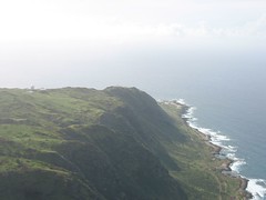 What a crazy place: our other mile-long thousand-foot-high ridge soaring site! This one has more interesting air traffic though: instead of the usual hang gliders and tour copters, here we have to watch out for sailplanes and their tugs, ultralight hang glider trikes, and skydive planes (not to mention skydivers). Then there's the air force radar array at Kaena point, which we've been told will microwave our gonads if we fly near them during space shuttle missions. That didn't seem to bother Ray - this was his first good day flying this site after several previous attempts, and he was thoroughly enjoying himself, running the length of the ridge all the way to the point and back, then out over Peacock Flats where the clouds started to get thick on the way to Mount Kaala. The three of us boated around happily in the smoothest of lift, a couple of thousand feet up most of the time, surfing above the orographic clouds that were forming below us on the ridges.
After a glorious hour and a half in the air, we saw a line of low clouds approaching from the ocean, and we decided to land before they arrived. The wind was starting to pick up too, and we found ourselves descending into some pretty turbulent air above our traditional landing area next to the old hangar. We all landed okay, but that was some of the worst swirling air I can ever remember landing in. Ray got a nice 30 percent whack about 20 feet off the tarmac, but managed to maintain his heading and land on his feet. That was a stressful way to end a very mellow flight. But apparently we had stumbled onto the perfect window of conditions for the day. There were kitesurfers launching at the beach as we left!
We celebrated our good fortune with brews and pupus at Jamieson's in Haleiwa before heading our separate ways to join our families for dinner. Thanks to Ray and Jon for their faith in my crazy idea today! I look forward to conducting more research out there.
6 comments:
What a great flight!!! that was the smoothest air in ages!! The scenery is gorgeous, with a lot of 4X4 trails, hiking trails.... we could see surfers, hikers, bikers, gliders, a huge albatross and makua!
as the white caps seem to get more consistent and abundant we made the right call to land. as we packed our gliders we could feel the wind swirling the LZ and the tress starting to move.
I almost stopped for a kiteboarding session (PG + KB in nuking conditions on the same day?) but was worried about having all the gear in the car parked at mokuleia and I thought we needed to celebrate that epic flight anyways...
It was funny how it turned windy all of a sudden! when we first got there I thought it was going to be a sledder for sure and almost didn't carry my pack with me!
Thanks Alex for convincing me to go there and Jon for showing the way!
hope to see you there next time!
One word - NICE!
Wish I went with ya. But Makapuu was fun too! and exciting.
maaaaan, i can't believe it ....
Alex called me to go beforehand, but i was already at Makapuu, gearing up into my snorkeling gear.
Hour and half in my ( ??? ;)) backyard ... duuude, really ??
Next time i'm in, for sure, call me, please ...
Where is the trailhead ? I feel like those conditions you described are out there a lot, i just never know how to get up to the launch.
Anyways, good for you guys, sounds and looks awesome !!!
We parked at the air traffic control tower at the gliderport, and hiked up the Kealia Trail, the DLNR trail (marked with a brown park sign) that switchbacks up the cliff face right behind the gliderport. It's a beautiful trail that continues up and over the mountains to a viewpoint overlooking Makua valley on the other side. The launch is a tiny little clearing just above the last switchback on the gliderport cliff face on the Kaala side, that can be reached with a little bushwhacking. That launch seems to be best in light north or even a little NNE.
There is another trail further towards Kaena point, past the end of the road, that requires 4WD, but you don't have to hike very far up. That one is better for stronger days, or maybe a little more NNW direction.
I've been out to Dillingham/Kaena Point many times, and I've been skunked on most of them. It's a lot trickier than you might imagine to figure out the airflow over there - it never seems to behave quite like we expect. Light north is my favorite condition out there at the moment.
Don noticed I took the last couple of pictures out over the water, and he pointed out something to me that should have been obvious, but somehow it wasn't: the airspace over the shoreline and ocean on the other side of the airfield is the landing approach corridor for the gliders and towcraft, and it's really a bad idea to fly over there. I wondered why that towplane came so close to me as I was heading back in! Let's use some sense when mixing with the traffic out there. I'll try to grow a brain for next time, and stay out of that corridor.
I flew a hang glider out there in the 90s on quite a few occasions using a truck tow to get to the ridge from the grass on the north side of the runway. Release at 1200 and glide to the ridge at about 600'.
It should be possible to use the short paved runway that faces NNE on the ridge side of the main runway (hasn't been used in decades) to scooter tow to about 600-700 feet and book back to the ridge after release. Save a big hike, just to sink out.
It's a bit compressed until you get to about 900-1000, but always seemed to work, and I was flying an crappy old 8:1 glider, so a PG should do better.
Post a Comment