


 I had a short window to play yesterday because of some family responsibilities, but I made the most of my limited time: a bunch of us flew out at Dillingham in perfect light post-frontal conditions.
 A phalanx of intrepid pilots marched up the cliff to test their launching skills at a variety of spots up top: Jon, San Diego Jason, me, Czech Peter, Jorge, Reaper, Sony, Brian, and Seattle Matt. Jackson Hole Andrew was getting his check off flight in a sailplane and flew fast circles around us for a couple of hours. Conditions were sweet and light - it was the most thermic day I've ever flown out there. Launching was a struggle for most pilots, since the airflow wasn't really moving across that little knob, and there's no space to run up there. I was lucky to get off first, and after a sweet hour and a half, I finally forced myself to land just in time to rush off and pick Amelia up from school.
I heard that there was a lot more great flying after I left: Jason got high over the main ridge for a sweet view of the west side, and lots of pilots flew out to Kaena point and back. Reaper got the short end of the stick though, being the last left on launch in the lightening breeze, and he finally opted to hike down.
I think we need to fly out there more often - I have a feeling it's flyable out there more often than we realize. Czech Peter seems determined to do some research on that subject, so stay tuned.
A few notes on the site for anyone not yet familiar with it:
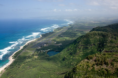
Conditions: most of the Mokuleia coastline faces due north. We typically fly out there on light north days, which are most common after cold fronts pass through in the wintertime. It's possible that light trades and sea breeze days could work as well.
Air traffic: At Dillingham we share the air with a wide variety of fellow flyers: sailplanes, towplanes, ultralight trikes, military helicopters, skydivers, albatrosses and boobies. When you get out there, please check in at the sailplane concession and let the two glider companies know you're planning to fly. Also call the UNICOM tower at 637-8271 and let them know where you plan to launch and land so they can give the other pilots a heads-up. Please DO NOT land on the beach in front of the airfield, since it lies directly beneath the aircraft landing approach pattern. Also, please leave the drop zone landing field to the skydivers.
Landing areas: the triangular grassy field next to the old roofless concrete bunker near the trailhead is a great place to land, especially if your car is parked at the tower. If in doubt about where to land near the gliderport, please discuss the options with UNICOM staff at the tower, and they can help you pick a safe spot. Of course, anyplace past the paved road towards Kaena Point is also fine.
Launches:
1. Kealia trail - a thousand feet of switchbacks leads to the top of the ridgeline behind the gliderport. Park at the ATC tower behind the gliderport and head back to the trailhead at the foot of the ridge. The launch areas we've used up there are quite committing: there is no room to run, and the air doesn't always flow through to help you inflate your wing.
2. Low launches - about a mile past the end of the paved road are the overgrown remains of an old access road that switchbacks up the ridge face, and there are a couple of decent low spots we've used to launch on stronger north days. To get out there you'll need a 4WD, or you could park at the road's end and hike out there.
3. West side access: in the old days, the guys used to get day-use permits (for hiking) from the DLNR office in town, and then drive their 4WD trucks around the west side to the Air Force gate at Yokohama Bay, and up the back to a nice grassy spot overlooking the Mokuleia coastline (past the end of the paved road). If you do it that way, you will want to be sure it's soarable so you can land back on top.
4 comments:
hey Alex, nice shots again, the one straight down, with HDH runway and sailplane is awesome, i need to step it up ;))
do you know by a chance, how to get up on that small hill E of launch ?? looks like there is a jeep trail and that spine has a house thermal, top of it has plenty of no winder options ...
czech
Bob's friend Jason drives 4WD trucks up on that ridge, and he has offered to take us up there to launch. They call it "the playground". I don't know the best way to get up there myself, but maybe Bob can ask his friend. I would think the best way for us would be to hike up the front.
Bob, let me please know what your buddy says, I'd love to take a ride up there and explore.
Alex, I didn't see any access on the front side. Also the farmer there is not all that friendly and you'd have to cross his property. He's had problems with skydivers before, retrieving their cutaways there.
Either way, that hill would be best for NE - Trades ... and light thermal days
czech
update on launchable/flyable conditions :
flew Dill again today ( 2.27.08 ), around 12.30
seemed like there should have been enough lift, gliderport windsock was NW, thermic pulses on launch, up to 5mph
once in the air, i felt rotor from the big rock on the west side of the lake, seabreeze was stronger out front then on the cliff face and more like WNW
should have tried right side of launch, but was hoping to get to the left, the big rock and the bowl it creates had to have some good lift, as it sticks out and WNW, but couldn't penetrate the venturi it created
had a sledder ;))
czech
Post a Comment