


 A few of our pilots have flown on Kauai: Jon (long ago), Scrappy and Ray (recently). There is one paraglider pilot who lives over there, Glenn, who occasionally flies a little hill near the prison. I just heard back from a Colorado pilot, Andy, who I had advised to contact Glenn - apparently he spoke with Glenn's wife and checked out Glenn's site, but he found another spot that looked better to him.
 Andy writes:
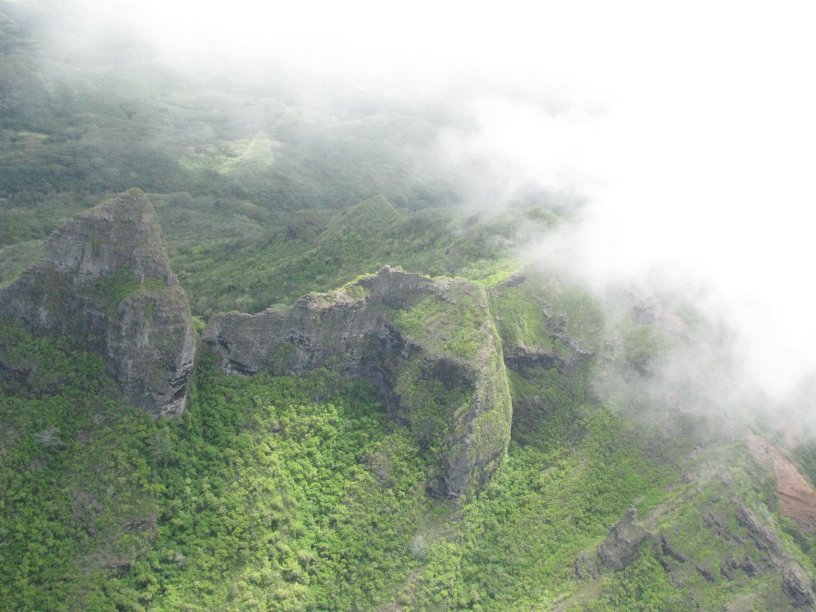
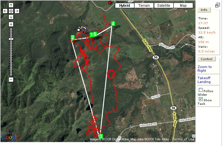
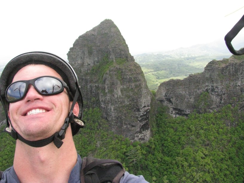
I ended up flying the Anahola Ridge/Mountain on Monday. I had a heck of a time finding a place to launch, and then once I thought I found one, it was another heck of a time getting to it, and it was only a couple hundred feet high, and the spot was barely large enough for my pack let alone my glider. But the conditions looked perfect and they were: E-NE at 5-10 mph I'd say, but great thermals cycles too. So I carefully balled up my glider and somehow I got it launched without any problems, still not really sure how I did it. It was probably the hardest/best launch I ever pulled off, probably because I really didn't want to pick my glider out of any of those bushes. I'm not even sure I could have if it had gone all the way in!
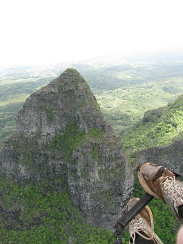
Anyways I launched off this little knob on the northern end of Anahola Ridge and I managed to get up to cloud base and over the biggest rocks, which is what I was after. It was spectacular. I knew there were plenty of helicopter/plane tours of the Na Pali coast (I saw them when I hiked the trail) so I did my best to check for them and such, but they didn't seem to be flying near this ridge at all, never had any encounters. I landed right back next to where I parked near the main highway in a little clearing (that does have a small "Keep Out" sign) and I balled my glider up and got on public grounds next to the highway ASAP. This field had nothing obvious going on at all, and I didn't feel like I was disrespecting it, or damaging it by landing in it.

I e-mailed back to ask some questions: how long did he have to hike? Could we call the launch "Andy's"? How much clearing would it take to make the launch worth using? How high did he get? Could he make the beach? How about over the back? Were there any people or livestock around? Would he mind if I posted his notes and pictures?
I think it took 20-30 minutes to get to the "launch" spot from the road. I'd be honored to have it named after me! It could be decent if a few bushes were cleared, but the way it was, I was almost falling off the slope to launch. The access was through a gate directly opposite an estate named "Tara." As I say, there was a small "Keep Out" sign, but it didn't look too serious. There was a washout/runoff sort of ditch that I encountered about halfway up that made it easier, but there was some nasty bushwacking to get to the runoff trail.
Max altitude was ~700 m, and that was probably 100-150 m above the lower cloudbase. I'm pretty sure I had the beach made on one glide, sort of wish I'd tried it or tried some other XC, but I really didn't want to land anywhere forbidden or land in any of that tall vegetation which I imagine would have destroyed my glider. I couldn't even think of going over the back since cloudbase was so low and all that terrain was in the clouds and it seemed like it was raining back there -- or at least it seemed low to me, since I'm from Colorado and we normally see cloudbase at 15-20,000 ft or even more -- but we don't always get to cloudbase either.
When I landed, some landscapers working out front of Tara gave me the hang-ten sign. Other than that, I didn't see anybody or any livestock, not even one of those roosters. There were a few white birds higher up near cloudbase, but they didn't seem to be soaring, even though I bet they were.
Certainly feel free to share my info/photos on your website if you think that's appropriate to do. I'm all about sharing and making things better if that's what will come of it.
I checked it out in Google Earth - as far as I can tell it's an ideal ridge for tradewind flying, facing ENE. Of course I don't know anything about the access issues over there, but it certainly bears further investigation. Any local pilots heading to Kauai anytime soon? Take your wing!
4 comments:
I'm surprised no comments on this yet. This sounds exciting.
I'm definitely "in" on any trip to go over and check this place out. I might need a day or two's notice. If it's tradewind friendly, it shouldn't be hard to find a good weekend this summer.
Thanks Andy! Good job, and nice pictures!!
-Jeff
good job, Andy! I am sure I know where you're talking about... I tried taking to some locals about hiking trails back there and I was told to avoid it because the "new" land owner (I was just a little west from your launch).
Everyday I drove by it I wondered about that place... I am glad you FLEW it! it is the P-e-r-f-e-c-t trades direction!!!
we should Glen know about it...
aloha
checking on google earth, I went on Hui road and talked with locals there... they told me the new guy closed the access to the hikes (private land) and the only way was to go around (from the back, over an hour hike)
Nice Andy!
I always thought about flying from the top of Kalalau (from Waimea Canyon) on a L&V day and flying the ridges all the way to Haena at the other end of the trail. I think it is possible, you just need to find the right day.
I am sure Kauai holds a bunch of flying sites, there is just a need for more hungry pilots over there.
Post a Comment