


This launch is a sprawling pasture in the middle of the north edge of the Kaena point ridge top, with a huge soft grassy area for taking off and top landing. It is one of the original launches pioneered by Reaper and his merry band of Cowboys before the dawn of time, a legendary launch site shrouded in mystery. I had only been there once, twelve years ago, in a scary 4WD mission to scope out wind conditions all over the point. We didn't fly Kaena that day, opting for the back of Makua Valley instead. That's another crazy legendary launch site. So I thought I remembered how to find the Kaena launch. Boy was I wrong!
I concocted a last minute idea for a mission the night before, signing up for a camping permit and three cars, naming ten pilots almost at random, and specifying three vehicles, hoping I could change the list depending on who ended up actually being available. Turns out you can't change the list! We managed to organize an early crew of those listed, consisting of me, Woody, BC Jayson, Oregonian Pete Reagan, Thom, Don, and BC PMac. Motorhead Paul ended up getting his own permit, as did visiting Oregonians Pete and Bill.
In hindsight, the camping permits are not as good as the hiking permits we've used in the past. The only good thing about the camping permit is you can sign up for it online and print it out at any hour of the day. But it does cost a few bucks (I paid $44 for 10 names), it's only good for a few nights, and it depends on the availability of campsites. The list of people must be spelled out, and I don't think it's possible to make changes once they're listed. We were asked for the ID of each person on our list at the guard shack.
On the other hand, the hiking permits require that you visit (or fax) the downtown office during working hours. But they are good for a much longer period, like 10 or 14 days, and you can specify up to five vehicles, and you don't have to name anyone other than the permit holder. You can bring as many people as your vehicles can legally hold. And, hiking permits don't depend on availability of campsites, and they don't deprive actual campers from sites they might want to sign up for.
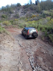
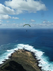
Finally we figured out where to park and walk through the chained off gate down a dirt road, about 15 minutes, to the bottom of the pasture at the cliff edge. It was just like I remembered it! A gorgeous mammoth grassy cliffside launch! The sensor at the airfield was calling the wind around 5 mph from due north, and up at launch we were feeling around 15. It really doesn't take much. It's a lot like the venturi effect we get up at Makapuu's Cactus launch - the less wind down below the better for your conditions on top. Getting off of there wasn't bad, but it was just about as strong as we could handle for top landing. And you have to top land here, or else you'll be waiting many hours down below for a possible ride out of there, or hiking a couple hours around the point back to the west side.
I think that launch is the Torrey Pines of Oahu launches. It's perfect. If only we had light north conditions more often. I'm not sure how much tolerance that launch will have for cross conditions, but I could picture it working anywhere from about 45 degrees from either side, from NW to NE. We'll just have to do more research to figure that out!
Now I have a new idea for accessing that amazing pasture launch. The thing is, it's nice to drive up there, but there's that permit issue, and it's at least a two hour drive from my house plus 15 minutes of walking. Now I am curious if it would be worth it to hike up from the bottom. There is a really smooth and shallow gully with a stream bed that leads up to that launch area, from a spot about a half mile past the end of the paved road on the Dillingham side. The next time we have light north conditions I'm going to check that out for sure. I think I could be up on launch a lot quicker that way - a 45 minute drive and a thirty minute hike up the front would save me an hour over the backside option!
2 comments:
Thanks for the write.
Awesome launch and flight, whales and Bernie buzzing us in his Glider plane was so cool.
This is a must launch but if you drive up you better top land or your stuck down below.
I am hoping you will find a hike up spot. I am in for that one too.
So nice to read of my 'putt putt zone' being the best launch too. Since I would putt putt my way up from the beach park at Dill. , I had no long drive to get up & soar. The birds also came by to show me where 'lift' was. What if Pete set up his scooter-tow there at Dill. to make long drive not needed to get some 'air-time' at this nice flight zone? It might becme a 'most fly' of all Oahu! Aloha kohalabeeman
Post a Comment