


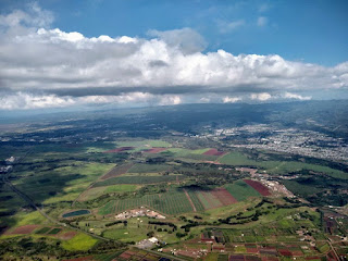
On most days, the central flatlands of O'ahu are not an inviting place to fly a paraglider. When the trades are blowing, ragged stacks of cumulus tumble over the Ko'olau range into the saddle that connects the Honolulu suburbs with the North Shore. Here they regain some form passing over subdivisions, solar farms and agriculture land before getting supercharged in the Waianae mountains. If the winds are strong, the hot turbulent soup is swept westward, out to sea in long cloud streets that mark our position long before the island itself can be sighted on the horizon. When the air is still, low pressure systems usually provide ample moisture that collects in the gulches and the vegetation, until the morning sun lights the fuse. By lunchtime the cumulonimbus are breathing deep and by afternoon the center of island is cast into shadow and rain.


The Stage


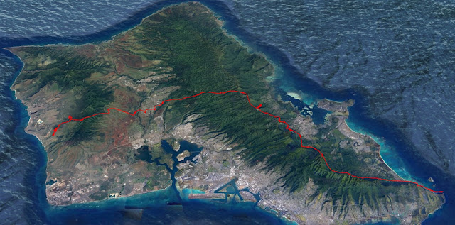
The quality of the sky may be impressive, but there are some reasons why pilots are not often romping through the playground. Flats being flat, the only current option for foot launching is to get up and over the back of the mountains. This is a reasonable prospect coming from Nanakuli since the conditions that work well on the westside produce cooperative skies in the central belt. Chipping over the back of the Ko'olau is a different animal since the light sea breeze days tend to be pretty hard work getting downrange from the established launches at Makapu'u or Kahana. If you top out a thermal at 3,800 feet at the back of Waikane and point it towards Waipio there's no guarantee of making it out of the mountains on glide. It's a committing move best suited for someone who is either pretty sure they are going to find another climb, or who doesn't mind finding a ridge line LZ amidst the ferns and strawberry guava, and hoofing it out.


ACT I: The Price of Entry

Marcel's radio was not transmitting properly, and his whereabouts remained a mystery until I was able to check my phone later in the flight. JK had done a warmup lap running a clockwise perimeter of the valley before re-joining the house thermal, announcing his return on radio "Who's ready to get high and go somewhere?" as if we had just been bopping around waiting for him to finish his calisthenics. As it turns out, Marcel had set to work breaking trail to the north, leading the charge to our declared goal of Dillingham. He was able to connect with the low spine that runs through the back of Waianae, but slowly lost the battle against a strong sea breeze, deciding that the back terrain was too risky with the strong wind so close to the looming venturi of Kolekole pass. With JK joining me we had double the search power and it wasn't long before we topped out the frisky thermal over the front peak and connected to lift along the back crest. The base ebbed and flowed with active cloud roiling around but we had a few hundred feet of clearance to scan around and plan the next move. The route along the crest to the north looked like it would go as far as the pass, but the back of Makaha was already buried in tall cumulus. That left us with two options: Retreat, or escape to the east. We were too high and close to base to see the sky in the flats, but the first few miles of terrain was visible and it was good. Dark, crisp shadows marked a checkerboard across the ag lands of Kunia. After confirming wind speed and direction (5 mph, southwest) we went on glide from 3,800 feet. Seven minutes later and twelve hundred feet lower, JK's Alpina hooked a hard left turn thirty seconds in front of me. I pushed bar to intercept his thermal before the ladder was pulled up underneath him. Three minutes later we had climbed 1,800 feet back to base in smooth lift. The day was in play.
ACT II: The Flow of the Day

Our short trip inland away from the sea air improved the cloudbase by six hundred feet. We had two thirds of a vertical mile between the ground and cloud to work with as we veered south away from the Wheeler airspace. A blue hole lay directly in front of us, and I radioed JK my intention to hug the northern border. I wanted to stick close to the edge of airspace to stay in reach of the convergence band draped across Mililani. He had chosen the southern edge of the hole, giving the airspace a wider berth. The time it took us to communicate our plans left us on opposite sides of the hole. I consider this moment the biggest mistake of our flight, since by the time our lines converged on the far side, I found a lazy climb but he was too far out to double back and join, and continued towards Waipio towards the next best looking trigger. The situation could have been reversed, had he found a thermal first I would have been too far out to pounce.

By allowing ourselves to be separated we negated the advantage of team flying. You need to be close, ideally within a hundred yards to jump on the other pilot's climb or effectively sample the air left to right on a glide. We wound up in our own climbs a mile apart, within sight of each other but essentially flying on our own. For the next thirty minutes we slowly made our way east, keeping tabs on each other's position and intentions via radio. I thought there was a chance we could still make Dillingham by carving a vast counterclockwise detour around Wheeler and re-connecting with the Waianae range in the Mokule'ia Forest Reserve. JK reported weak climbs further south over the Waipio Costco, and he let me know that he was trending south in an effort to follow the sun patches and avoid the deep shade. At the time however, I was allowing the weak sea breeze to frisbee me north into a shady zone of abundant lift just mauka of Mililani town, and it was apparent that the closer I flew to the dark cloud band, the better the lift. The convergence was working great. I would top out a climb at base and push out on bar to get clear, then dip a toe back in when necessary. The idea of continuing north, punching under that dark belt to Mokule'ia was suddenly loony. It was impossible to see the extent of the development in the thick mass, and I had visions of getting hoovered up into one of those cu-nims that eventually consumes the whole center of the island. The picture to the east was playful in comparison. A path of high cloud extended almost to the crest of the Ko'olau, intersecting the range somewhere behind Waikane. The deal was sealed by the fact that the upper wind layer was gently pushing east, meaning that every second spent turning circles was also scooting us towards our home turf on the peaks of the Ko'olau.


ACT III: Every Foot Counts
It would be slightly incorrect to say we soared down the range. There was anabatic flow which collected in some areas and not others, but often as not you would feel a little burble off your wingtip, search out and find a weak thermal that would allow you to turn 360's quite close to the mountain without drifting into the face. It was a grueling test of discipline to keep making progress downrange, searching for scraps on each successive feature that would allow upward progress. It was grinding, slow work and I was more than happy to let my wingman break the trail. This flight was only my third time traversing the section between Kahulu'u and the Pali. JK did one hundred percent of the hard work on this grinder of a home stretch. I would sit tight and top off while he hunted further, then elbow my way in like a hyena on his prey. It took an hour to make it to the Likelike tunnels, we could have gone faster on beach cruisers. I stopped to enjoy a sweet climb almost directly over the Pali gap, and you can just see the beginning of a light north wind pulling through on the tracklog. As we rounded the flank of Konahuanui, Jorge came on radio having spotted us from Green Walls where he and visitor Yun were working to get above ridge height, coming the other way from Makapu'u. I couldn't see them, but hearing Jorge's stoke was a major boost. The fact that they were doing well meant that the rest of the route would go- it was just a matter of holding our shit together and keeping it between the lines.

The Big Link-up: Fever Dream or Low-Hanging Fruit?
Just how hard is it to link the ranges? To answer the question it may be useful to come up with a paragliding version of the Drake Equation. In the early sixties, astronomer Frank Drake developed a formula to estimate the number of detectable alien civilizations in existence. It's basically a long list of probabilities multiplied together. If we were to estimate the number of days per year we could link up our flying sites on opposite ends of the island we would tally up the number of days with light wind, ok stability (no overdevelopment), and high base. Then we would need to figure in the pilot-specific factors. An enthusiastic intermediate pilot like myself needs much better conditions to make it through than the real pros. An organized team will have a better chance than a solo charger at solving the tricky cruxes so we would figure that in. Finally, you would factor in the declared goal, since it makes a difference if you choose to fly west versus heading east. The only reason I believe this might be useful is to figure out which factors are the real deal breakers and which can be overcome with skill and planning. The wind is a deal breaker, low base is a deal breaker, and the rest is negotiable. For instance, I could see a motivated group of pilots making it happen on a normal light/variable day that eventually overdevelops by getting an early start on the west side, slipping over the back before it consolidates in the high ground, then crossing the flats as things really start to pop. Once you've decided on the go/no-go factors, it's just a matter of getting better at forecasting so that you can be in the right place at the right time with the right plan, and the willingness to scrap the plan if it looks like the sky is taking you somewhere else.
There are a number of other aesthetic or adventurous lines I hope to fly that are not necessarily that big, but the obvious mic-drop line of the island would be Makapu'u to the tip of Ka'ena, or vice versa. Maybe the perfect day for this one would start with light trades in the morning to allow an early launch, but then dropping to light/variable once the pilots are in position to cross over. The convergence would then be just starting to turn on when the team hits the flats, before the sea breeze shoves all the popcorn cumulus into a thick dark band in the middle. If the team made it to the Waianae range before the eastern slopes go into the shade, they would have a better chance of benching up and over. This section is the last unsolved piece of the puzzle. Our linkup pioneer, Doug Hoffman, has connected the dots from Makapu'u across the flats but hasn't yet gotten established in the Waianae range. Nanakuli to Ka'ena is a challenging flight, but it's been done before; it's not a mystery how to make it go, and the route should work late into the day moving towards towards the setting sun. What about going west-east? The fact that JK and I made it through on my first foray into the flats is evidence that from Nanakuli on, it isn't too hard on the right day. The Ka'ena point launch doesn't start working until the sea breeze starts to pull through in the late morning. This could make it tough to get to the Ko'olau crossing in time to catch the powerful part of the day. Perhaps some work is required to figure out the northern line from Makua - Mokule'ia Forest Reserve - Dole Plantation, then follow the Poamoho trail up to Booga Booga Land. Alternatively, from the northern flank of Ka'ala we could cut straight across Wheeler on a weekend day the tower is not active. All of this talk is purely academic navel-gazing without the weather to make it happen, so the question remains- How often will it work?
To help put the question in context I reached out to a number of pilots who have some knowledge of flying the high days in interesting places. Last year, Colorado pilot Kris Holub observed the convergence between the ranges and figured he'd give it a crack at the first opportunity. Before his vacation was over he had sent the line from Nanakuli to Kaneohe. A couple weeks ago I asked him about the flight and he described the last leg to reach the Ko'olau crest as touch and go, without much buffer and was calculating his glide to the lone red dirt bailout LZ he could see high on the backside of the range. He found no lift at the crest itself and headed out in search of a thermal off the flats. Finding none he put it down at the community college. From his description it sounds like he had a lower base than we did, but pretty consistent across the saddle. I wonder if Kris actually had pretty similar conditions on the Ko'olau to JK and me, since we also found dead air on top of the range. JK's experience was what kept us going at that crux point since he recognized that it was time to switch gears and start scratching tight.
I actually launched a few minutes after Kris did that day December 28 2020, on my first ever flight on the westside. The base was only good, not spectacular. Add a check mark to the "Probably works more than we think" column. My flight log for the day reads "Failed first two inflations. Easy up on the third. Sharp thermals, active input required. Marcel to Makua, Kris to Kaneohe". Marcel's Makua roundtrip makes me think in hindsight that had someone been able to get up from Ka'ena, they could have pulled off the linkup. Because Kris also made it on his first try, I believe that indicates the route likely is working pretty well much of the time when the flats look inviting. One advantage of the western approach is that you can get going from Nanakuli in the morning and hit the flats in the "dreamscape" part of the day. So often, the perfect paragliding sky either explodes in overdevelopment, or hits the inversion and spreads out into a thick grey ceiling after all the cumulus get swept into the powerful middle section of the island. The sea breeze peaks in mid afternoon, so a route that might be a cloud hopping delight earlier in the day could be plagued by wind and broken lift in the afternoon. Makapu'u generally isn't working early on the light days (or is it?) and it's a much longer trip to get established in the middle of the range at a good spot to huck over. The other advantage of crossing the Ko'olau from the west is that you have the luxury of finding the booming convergence lift before committing to the line. Going east to west requires more confidence in your onsite forecasting, a prospect that has deterred almost all suitors.
The best looking day I've ever seen for high altitude shenanigans was in the first week of February 2021, which I watched unfold from my job in town. There was a ridiculously high cloud street setting up slightly on the town side of the Ko'olau, extending into a neat intersection with the east-west convergence line. I did my best via text messaging to goad my buddies into lobbing over the back into that cloud street, but it's much easier to talk crap than it is to actually make the moves. It turned out to be a spectacular day on the range, but far from straightforward. A good percentage of the pilots were grounded before making it as far as Ahuimanu. Adam Fishbach had a banger of a day team flying with Austin Cox and Matt Senior from Manics to Kahuku, and I called him recently to get the breakdown of their day wearing my convergence-tinted glasses. He reported a playful start in light north flow that you would expect on a sea breeze day, noodling around doing laps out to sea from the lighthouse before heading downrange and getting the first big climb at Pu'u o Kona to four grand. They went on glide following the crest, finding modest bumps at the usual triggers until getting stuck low at the Likelike tunnels. They recovered and hooked into the booming thermal at Pu'u Keahi a Kahoe above the microwave relay station, and again boosting above four grand at 'Eleao. As they passed behind Waikane, Adam recalled Matty on the deeper line suddenly flicking into orbit and by the time Adam adjusted to join in, the door had closed and he was unable to get on the ride. This was just a bit north of where JK and I crossed the crest, and I'm not certain if this was related to the east-west convergence versus a more local effect. I asked Adam if he recalled spotting the convergence line between the ranges or if they contemplated going over the back, and he said that from their vantage point, visibility in that direction was limited by cloud and it wasn't the goal to link up to the westside, they were trying to nail up the entire length of the Ko'olau. I reviewed his excellent video from that day, and in the final phase of his flight after he has climbed back up from Sacred Falls you can see the convergence

No one has more miles in the O'ahu flatlands than Doug Hoffman, so I was stoked when he reached out after my flight with JK to share a ton of beta. He's gone over the back of both ranges plenty of times over the years, with minimum fuss. Last season I remember flying a nice day at the back of Punalu'u when I heard this call on radio: "This is Doug, I'm going over the back. On purpose." For the pilot with the appropriate skill set, the best strategy is simply to try it every chance you get. If the goal is to get all the way out to Ka'ena point, I see some advantages in his favored east-west route. Ka'ena is at the mercy of the sea breeze, so it could be a pretty tough spot to start. Even if you launch elsewhere on the west side and try to tag it and return, it would require exceptionally good conditions to get that segment done before tackling the convergence during the strong part of the day. By contrast if you are heading west at the end of the day, you could make the bird sanctuary on glide from a strong position high between Makaha and Makua. The major disadvantage of going east- west in my opinion is that you hit the flatland crux- benching up and over the Waianae range- later in the day when the slopes are shaded. In the mid afternoon it's also more likely to be torn up by the sea breeze. Perhaps some towing in Kunia could help us practice this crux?
As we continue to map out the interesting routes on the island, I think the greatest chance for improvement in our success is practicing structured team flying. At the risk of stating the obvious, it's relatively easy to make progress up and down a single range as a solo pilot because the triggers are in plain sight, on a straight line. If one isn't working, you keep going to the next, not exactly rocket science. The flats, in comparison, can be an easy place to bomb out and the multiplied search power of an organized team should help greatly. JK and I traded leads between Nanakuli and the Ko'olau which allowed the route to go. I think that's one of the major reasons that visiting pilots have good success coming over in the winter and sending big lines. They are out chasing it every single day, looking to go big as a group. By comparison, we locals are flying when we're off work, with whoever else happens to be motivated that day. One way around this conundrum is for enough of us to plan some big chunks of time off in the winter to start banging out some group attempts whenever the weather allows.
I've had a blast this winter flying all over the island with our motley crew. I'm still in the phase of my progression where hiking with friends learning about the weather constitutes a great day out. The chance of exploring new ground by air is just gravy heaped onto the fun pile. Thanks much to all the pilots who invite me along on their missions and share their knowledge. I'm learning a ton from the monkey pack, and these write-ups are my way of getting it all onto the record. If we cross paths in the sky, toss me your keys and we'll trade stories at the end of the day.
- Patrick
https://ayvri.com/scene/mxkox428k4/ckz9gh2qb00003c64fiz5dba5
5 comments:
What a thought-provoking and detailed write up, Patrick, you have a gift with words. With this kind of insight, a Kaena Point to Makapu’u state record is just a matter of time and conditions. That flight we had together was perhaps my most enjoyable on Oahu. It would only have been better if Tim & Marcel could have made it with us. Team flying is such a magnifier. Thanks for making it twice the fun!
What a thought-provoking and detailed write up, Patrick, you have a gift with words. With this kind of insight, a Kaena Point to Makapu’u state record is just a matter of time and conditions. That flight we had together was perhaps my most enjoyable on Oahu. It would only have been better if Tim & Marcel could have made it with us. Team flying is such a magnifier. Thanks for making it twice the fun!
Patrick, That was an epic flight you and JK put in that day. You called it and then flew it. The fact that you put it down in words is even better so others can look at it and learn from your work for years.
Wow thanks.
JJJameson is smiling somewhere.
Amazing flight, great read.
Thanks
Nice writeup!
-Josh Cohn
Post a Comment