


 I love to fly our usual sites, especially when we have lots of pilots available. But sometimes it's fun to enjoy a special adventure with just a couple of friends. Today, Scot led new Oahu pilot Laurel and me on a very cool mission to discover a new launch at Dillingham.
 It was blowing a moderate postfrontal north all around the island, although it was coming in a bit east of north at Dillingham with plenty of whitecaps on the water. When I first arrived at about noon, the Mokuleia sensor was reporting a 9 mph average at 42 degrees. It felt like it was blowing about 12-15 at the end of the paved road, and definitely pretty cross from the east. Normally we like it light north out there, but we've flown it on moderate north days when we can hike up and launch low enough.
We didn't really plan to discover a new launch. But we didn't have a 4WD vehicle to get past the end of the paved road to reach our sketchy switchback launches, and even if we did, the direction was probably too east for that ridge. The Kealia launch faces more east, but we thought it was too strong to hike to the launch spot we use at the top of that ridge, and I'm not aware of any decent low launch spots along the Kealia trail before it emerges from the trees at the ridge crest.
My lame idea was to try kiting and/or soaring the dunes at the end of the paved road. They're not very big, and would probably need a bit more wind, although the power lines are a bit close for strong wind kiting there. I also thought maybe I could try kiting up the hill in the grassy bowl behind the parking area. Maybe I would get airborne before I got too far up the slope. Although the grass looks tall and there are probably boulders hidden in it.
Scot asked if I'd ever considered launching from anywhere along the trail to the climbing wall. I'd heard that there was a climbing spot out there but I'd never seen it. Turns out it's right there between our Kealia and switchback launches, well before the end of the paved road, behind Camp Erdman. Scot has climbed there before (and I know Dave has too), so he knew exactly where it was. Scot had a plan to diverge from the trail about halfway to the climbing wall, to check out the possibility of launching from some nice looking grass covered slopes up there. Laurel and I were both game for that adventure.
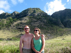
Laurel recently moved here from the Big Island. She's attending UH to get a doctorate in architecture, and she's planning on doing without a car. (Scot kindly picked her up today to join our adventure team.) She is a pretty new pilot but I have heard from the Big Island guys that she's a natural in thermals. And even though she is new to Oahu, new to ridge soaring, and certainly new to sketchy Dillingham launches, she gamely hiked up with us to pioneer a new launch site, lugging her gear but armed with a healthy dose of skepticism.
We parked at the trailhead and started up the trail. It's not quite as civilized as the Kealia trail, but it's pretty well cleared. After about 10 minutes we left the trail and traversed an old rockslide to reach a nice grassy bowl with good launch potential, about 500 feet above the road. We cleared out the dead burned up trees and Scot laid his glider out. I was glad he was willing to go first, because even though the launch looked doable, I wasn't happy about the gusty cycles and the cross direction. Although we were happy to note that the sensor was starting to report a better direction for the Dillingham ridge, a more reasonable 17 degrees.
Scot's launch was pretty exciting, and he was sucked up and away in some big swirly gusts. After some discussion with me, Laurel decided she'd probably be hiking down, a good conservative decision. I laid out next, and with Laurel's help I was able to build a good wall and get out of there without too much trouble. The launch is similar to Tomato Patch, but not quite as steep, and with better airflow. I was sucked up and away to join Scot. I was euphoric to be in the air on a flyable day out there, but I was also a bit upset because I realized I had lost my phone just as I launched. Thankfully Scot was able to dial it and Laurel heard it ringing from a crevice between some rocks. Whew!
Scot and I flew up and down the ridge in big juicy ridge lift with some nice fat thermals mixed in. The lighting at that time of day was gorgeous, and the view was clear in all directions. Mt. Kaala was slightly in the clouds, but we weren't really planning to go that far anyway. Scot flew the furthest in each direction, while I was happy to just boat around behind him and take pictures. What a view. We shared the air with a sailplane, the funny little one with the curved up pointy wingtips. He gave us a wag of his wings during his first pass. I tried to wag back at him but it doesn't really have the same effect in a paraglider. Oh well.
Finally we heard Laurel's voice over the radio: Guys, I think I'm gonna launch after all! We flew back to check on her and she was carefully laying out. The conditions felt more mellow for sure, so we were encouraging her and giving her way too much advice. She made an excellent launch, but the wind was definitely getting lighter by then, averaging between 5 and 7 mph on the sensor, and she didn't have an easy time getting up, so she headed to the beach for a landing right across the street from where we had parked. Scot and I joined her down there soon afterward.
I think Scot deserves a special club medal of honor for discovering what seems to be an excellent new launch at Dillingham. No 4WD is required, and the hike is about the same as the ones at Kahana or Cactus. I'm guessing the launch will work fine in light to moderate winds from NNW to NNE. I'm hoping we get some more north days soon, so I can get back out there to find out!
I took video of Scot's launch and also took tons of pictures - but now my memory card is giving me trouble. It looks like it's completely unformatted. Oh well. Maybe the sheer beauty of the day just fried it. Hopefully Scot or Laurel managed to salvage a few shots from their cameras, and if so, I'll try to include them here when they come my way.
[Update: McStalker Jeff sent me a link for a memory card utility that allowed me to recover most of my photos and video, which I have now included in the story, along with photos from Scot and Laurel. Thanks Jeff, Scot and Laurel!]
6 comments:
Awesome Alex,
Another Great read
Great Story I had to cringe a little when I heard the reference to the "Patch"
You 3 should put a name on the launch for your exploration efforts.
Laurel Welcome to the Flying Monkeys.
Alex, there is a common denominator in all these stories that should be fixed.
PUT A LANYARD on THAT PHONE.
That launch looks almost civilized by Dill standards and much mor frienldy to our dillicate wings than bare lava! Clearly y'all hastened out there without dillay and were dilleriously happy to get a taste of the dillicious pickle! But beware - successfully launching Dill can lead to dillusions of grandeur amongst the unwary. What about all the poor local pilots who have been dilligently practicing their kiting skills just so they too could someday taste the pickle, but cannot do so because they are unfortunate enough to have a job??? This story with it's beautiful pictures isn't a dilliberate attempt to rub in those circumstances, is it?
Whats with the swinging? Was it that strong?
Reaper
Thom: good advice - today I kept the phone safe in my pocket.
Berndt: your comment cracked me up - thanks.
Reaper: it was pretty strong, but Scot also thinks he might have been a bit clumsy with the brake inputs.
I went back out there today with Jim and Jeff. Light north sea breeze all day, average 5-6, gusting to 7-8. Jim and I hiked up all the way to the climbing wall while Jeff stayed down below to protect the beer. There are no good places to launch up near the wall. But it was worth a visit just for the view and to see what those crazy climbers are doing up there - they were surprised to see us. So we hiked back down the trail and cut over when we thought we were near the top of the grassy patch, but it was really tough slogging. Finally we emerged at the top of the grass, pulled out a few burned up stumps, and trampled the grass a bit. Later on I realized that we were really not that far from where we launched the other day - probably just a hundred feet higher up. I asked Jim if he wanted to go first but he said it was too light for him to inflate. I laid out as Jim was navigating his way back to the trail, and I launched in a light cycle to get airborne. Meanwhile McStalker had got tired of waiting for the entertainment to begin, and had drunk most of the beers and was taking a dip in the ocean clad only in his underwear. Turns out I had launched with a hellacious riser twist/tangle on one side, and could barely pull the brake, so I grabbed the brake line above the pulley. But it's hard to thermal well like that, so I wasn't able to make much of the light lift. Who knows if I could have stayed up anyway, but it felt pretty buoyant. I checked the sensor later and it had dropped to 3 mph average right around the time I launched - that definitely wouldn't have helped. As I made my approach to land near the cars, I thought I saw the full moon rising right on the beach, but it was just Jeff putting his pants back on. I drank Jeff's last beer just in time for Jim to emerge from the trailhead. We all headed to Waialua for more provisions, slaking our mighty thirsts on the side of the road while we talked about our hopes and dreams for the Kaena Point sites, Dillingham and Makua. We'll definitely be back out there soon! Thanks to Jim for the hiking companionship, and to Jeff for the refreshments.
ashit ! ( as nepalese would say ). i've hiked up to the climbing wall a couple of times looking for a launch spot and never saw it ! good for you fellas ! except that means the old cliff-top Kealia launch will be over grown by the time i'll be back to huck it off of there, ya ?
where is the bomb out LZ ? the road ?
have fun at RTs bonfire everyone !
czech peter
@Czech Pete. It's pretty easy to make the beach on glide from the launch. If you don't feel like clearing the power lines there's a huge field of elephant grass on the near side of the road.
@Reap. I was running/stumbling/falling down the rocks backwards so my control was less than elegant. :( I also hit a rock or stump just as I became airborne, fortunately I was still backwards and the harness took the hit. It was pretty hard. I didn't blow the launch though so I don't owe you an hour of kiting. ;D
One thing I have noticed about this wing is it's heavy. Normally not an issue, but I definitely feel it when trying to get inflated in really light conditions, hence the run.
Post a Comment